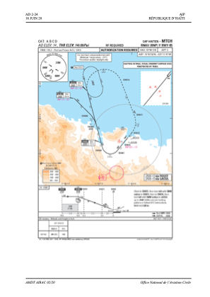
IAC chart of MTCH
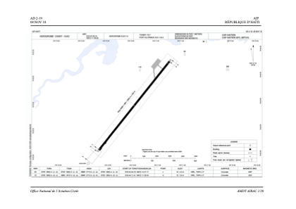
 ADC chart of MTCH
 Satellite view of MTCH
ADC chart of MTCH
Satellite view of MTCH
Sorry, we have no imagery here.
Sorry, we have no imagery here.
Sorry, we have no imagery here.
Sorry, we have no imagery here.
Sorry, we have no imagery here.
Sorry, we have no imagery here.


MTCH - Cap-Haitien
Located in Cap Haitien, Haiti
ICAO - MTCH, IATA - CAP
Data provided by AirmateGeneral information
Coordinates: N19°43'58" W72°11'41"
Elevation is 14 feet MSL.
View others Airports in Nord Department
Operational data
Special qualification required
Current time UTC:
Current local time:
Weather
TAF: TAF MTCH 111740 1118/1218 36004KT 8000 SCT020CB OVC050 TEMPO 1121/1209 4500 TSRA FM121000 VRB02KT 7000 SCT020 BECMG 1213/1215 02012KT
Communications frequencies: [VIEW]
Runways:
| RWY identifier | QFU | Length (ft) | Width (ft) | Surface | LDA (ft) |
| 05 | 39° | 8701 | 148 | ASP | |
| 23 | 219° | 8701 | 148 | ASP |
Airport contact information
Address: Cap Haitien Haiti
Satellite view of MTCH
Sorry, we have no imagery here.
Sorry, we have no imagery here.
Sorry, we have no imagery here.
Sorry, we have no imagery here.
Sorry, we have no imagery here.
Sorry, we have no imagery here.