ADC chart of MO66
 Satellite view of MO66
Satellite view of MO66
Sorry, we have no imagery here.
Sorry, we have no imagery here.
Sorry, we have no imagery here.
Sorry, we have no imagery here.
Sorry, we have no imagery here.
Sorry, we have no imagery here.


MO66 - Linden Air
Located in Ozark, United States
ICAO - MO66, IATA -
Data provided by AirmateGeneral information
Coordinates: N37°3'32" W93°8'43"
Elevation is 1300 feet MSL.
View others Airports in Missouri
Operational data
Special qualification required
Current time UTC:
Current local time:
Weather at : KSGF - Springfield-Branson Ntl ( 30 km )
METAR: KSGF 051052Z 01015KT 6SM BR OVC005 07/06 A3001 RMK AO2 SLP165 T00670061
TAF: KSGF 050520Z 0506/0606 36014KT P6SM OVC004 FM051100 01018G25KT P6SM OVC003 FM051400 01015G24KT 4SM -RA BR OVC007 FM060200 01018G25KT P6SM OVC007
Communications frequencies: [VIEW]
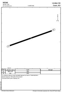
Runways:
| RWY identifier | QFU | Length (ft) | Width (ft) | Surface | LDA (ft) |
| 07 | 70° | 2850 | 80 | GRASS | |
| 25 | 250° | 2850 | 80 | GRASS |
Airport contact information
Address: Ozark United States
Satellite view of MO66
Sorry, we have no imagery here.
Sorry, we have no imagery here.
Sorry, we have no imagery here.
Sorry, we have no imagery here.
Sorry, we have no imagery here.
Sorry, we have no imagery here.