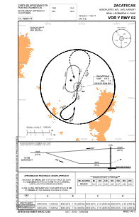
IAC chart of MMZC
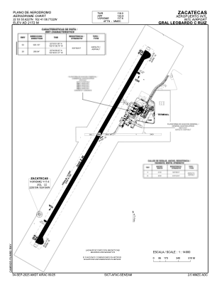
 ADC chart of MMZC
 Satellite view of MMZC
ADC chart of MMZC
Satellite view of MMZC
Sorry, we have no imagery here.
Sorry, we have no imagery here.
Sorry, we have no imagery here.
Sorry, we have no imagery here.
Sorry, we have no imagery here.
Sorry, we have no imagery here.


MMZC - Zacatecas Aeropuerto Internacional Gral. Leobardo C. Ruiz
Located in Zacatecas, Mexico
ICAO - MMZC, IATA - ZCL
Data provided by AirmateGeneral information
Coordinates: N22°53'51" W102°41'9"
Elevation is 7126 feet MSL.
View others Airports in Zacatecas
Operational data
Special qualification required
Current time UTC:
Current local time:
Weather
METAR: MMZC 091923Z E27010KT 6SM SKC 22/M07 A3032 RMK FU OVR RWY VIS N 02SM
TAF: TAF MMZC 091621Z 0918/1018 06010KT P6SM SKC TX21/0921Z TN06/1012Z FM100300 06005KT P6SM SKC FM101600 06010KT P6SM SKC
Communications frequencies: [VIEW]
Runways:
| RWY identifier | QFU | Length (ft) | Width (ft) | Surface | LDA (ft) |
| 02 | 28° | 9843 | 148 | ASP | |
| 20 | 208° | 9843 | 148 | ASP |
Airport contact information
Address: Zacatecas Mexico
Satellite view of MMZC
Sorry, we have no imagery here.
Sorry, we have no imagery here.
Sorry, we have no imagery here.
Sorry, we have no imagery here.
Sorry, we have no imagery here.
Sorry, we have no imagery here.