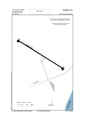
ADC chart of MMTU
 Satellite view of MMTU
Satellite view of MMTU
Sorry, we have no imagery here.
Sorry, we have no imagery here.
Sorry, we have no imagery here.
Sorry, we have no imagery here.
Sorry, we have no imagery here.
Sorry, we have no imagery here.


MMTU - Tulum Naval Air Station
Located in Tulum, Mexico
ICAO - MMTU, IATA - TUY
Data provided by AirmateGeneral information
Coordinates: N20°13'38" W87°26'18"
Elevation is 7 feet MSL.
Magnetic variation is -2° East View others Airports in Quintana Roo
Operational data
Special qualification required
Current time UTC:
Current local time:
Weather at : MMCZ - Cozumel Aeropuerto Internacional ( 62 km )
METAR: MMCZ 071340Z 14009G19KT 8SM SCT015 29/23 A2989 RMK 8/500 HZY
TAF: TAF MMCZ 071102Z 0712/0812 13005KT P6SM SCT015 FM071600 12010KT P6SM SCT015 PROB40 0723/0803 3SM TSRA BKN015CB FM080300 33010KT 6SM VC RA BKN020 FM080600 34010KT 5SM RA BKN015 OVC080
Communications frequencies: [VIEW]
Runways:
| RWY identifier | QFU | Length (ft) | Width (ft) | Surface | LDA (ft) |
| 12 | 124° | 5862 | 82 | CONC | |
| 30 | 304° | 5862 | 82 | CONC |
Airport contact information
Address: Tulum Mexico
Satellite view of MMTU
Sorry, we have no imagery here.
Sorry, we have no imagery here.
Sorry, we have no imagery here.
Sorry, we have no imagery here.
Sorry, we have no imagery here.
Sorry, we have no imagery here.