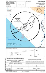
IAC chart of MMTP
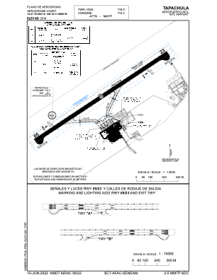
 ADC chart of MMTP
 Satellite view of MMTP
ADC chart of MMTP
Satellite view of MMTP
Sorry, we have no imagery here.
Sorry, we have no imagery here.
Sorry, we have no imagery here.
Sorry, we have no imagery here.
Sorry, we have no imagery here.
Sorry, we have no imagery here.


MMTP - Tapachula Aeropuerto Internacional
Located in Tapachula, Mexico
ICAO - MMTP, IATA - TAP
Data provided by AirmateGeneral information
Coordinates: N14°47'40" W92°22'12"
Elevation is 97 feet MSL.
View others Airports in Chiapas
Operational data
Special qualification required
Current time UTC:
Current local time:
Weather
METAR: MMTP 092340Z 23007KT 8SM SCT100 SCT180 31/23 A2987 RMK SLP140 52002 912 8/051 TWR HZY
Communications frequencies: [VIEW]
Runways:
| RWY identifier | QFU | Length (ft) | Width (ft) | Surface | LDA (ft) |
| 05 | 56° | 6562 | 148 | ASP | |
| 23 | 236° | 6562 | 148 | ASP |
Airport contact information
Address: Tapachula Mexico
Satellite view of MMTP
Sorry, we have no imagery here.
Sorry, we have no imagery here.
Sorry, we have no imagery here.
Sorry, we have no imagery here.
Sorry, we have no imagery here.
Sorry, we have no imagery here.