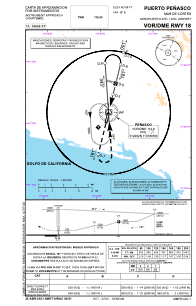
IAC chart of MMPE
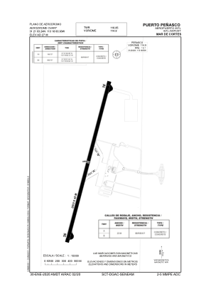
 ADC chart of MMPE
 Satellite view of MMPE
ADC chart of MMPE
Satellite view of MMPE
Sorry, we have no imagery here.
Sorry, we have no imagery here.
Sorry, we have no imagery here.
Sorry, we have no imagery here.
Sorry, we have no imagery here.
Sorry, we have no imagery here.


MMPE - Puerto Penasco Mar De Cortes Aeropuerto Internacional
Located in Puerto Penasco, Mexico
ICAO - MMPE, IATA - PPE
Data provided by AirmateGeneral information
Coordinates: N31°21'7" W113°18'20"
Elevation is 88 feet MSL.
View others Airports in Sonora
Operational data
Special qualification required
Current time UTC:
Current local time:
Weather
TAF: TAF MMPE 100416Z 1006/1106 20006KT P6SM SKC FM101800 35010KT P6SM SCT250 FM110500 00000KT P6SM SKC
Communications frequencies: [VIEW]
Runways:
| RWY identifier | QFU | Length (ft) | Width (ft) | Surface | LDA (ft) |
| 18 | 193° | 8202 | 148 | UNK | |
| 36 | 13° | 8202 | 148 | UNK |
Airport contact information
Address: Puerto Penasco Mexico
Satellite view of MMPE
Sorry, we have no imagery here.
Sorry, we have no imagery here.
Sorry, we have no imagery here.
Sorry, we have no imagery here.
Sorry, we have no imagery here.
Sorry, we have no imagery here.