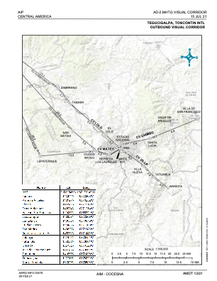
VAC chart of MHTG
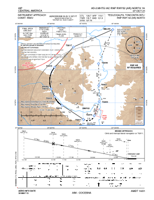
 IAC chart of MHTG
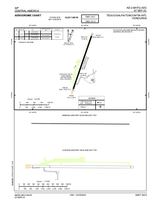
 ADC chart of MHTG
 Satellite view of MHTG
IAC chart of MHTGADC chart of MHTG
Satellite view of MHTG
Sorry, we have no imagery here.
Sorry, we have no imagery here.
Sorry, we have no imagery here.
Sorry, we have no imagery here.
Sorry, we have no imagery here.
Sorry, we have no imagery here.


MHTG - Toncontin
Located in Tegucigalpa, Honduras
ICAO - MHTG, IATA - TGU
Data provided by AirmateGeneral information
Coordinates: N14°3'37" W87°13'3"
Elevation is 3307 feet MSL.
View others Airports in Francisco Morazan
Operational data
Special qualification required
Current time UTC:
Current local time:
Weather
METAR: MHTG 061400Z 06004KT 9999 FEW030 22/14 Q1019 A3009 NOSIG
TAF: TAF MHTG 061100Z 0612/0712 VRB04KT 9999 SCT030 TX32/0621Z TN17/0712Z BECMG 0618/0620 06010KT BECMG 0600/0602 VRB04KT
Communications frequencies: [VIEW]
Runways:
| RWY identifier | QFU | Length (ft) | Width (ft) | Surface | LDA (ft) |
| 02 | 19° | 6631 | 148 | ASP | |
| 20 | 199° | 6631 | 148 | ASP |
Airport contact information
Address: Tegucigalpa Honduras
Satellite view of MHTG
Sorry, we have no imagery here.
Sorry, we have no imagery here.
Sorry, we have no imagery here.
Sorry, we have no imagery here.
Sorry, we have no imagery here.
Sorry, we have no imagery here.