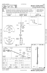
IAC chart of M95
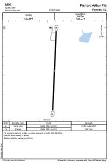
 ADC chart of M95
 Satellite view of M95
ADC chart of M95
Satellite view of M95
Sorry, we have no imagery here.
Sorry, we have no imagery here.
Sorry, we have no imagery here.
Sorry, we have no imagery here.
Sorry, we have no imagery here.
Sorry, we have no imagery here.


M95 - Richard Arthur Fld
Located in Fayette, United States
ICAO - M95, IATA -
Data provided by AirmateGeneral information
Coordinates: N33°42'33" W87°48'55"
Elevation is 357 feet MSL.
Magnetic variation is -03° East View others Airports in Alabama
Operational data
Special qualification required
Current time UTC:
Current local time:
Weather at : KJFX - Walker County/Bevill Fld ( 51 km )
METAR: KJFX 051035Z AUTO VRB05G10KT 10SM FEW017 BKN035 22/20 A3007 RMK AO2
Communications frequencies: [VIEW]
Runways:
| RWY identifier | QFU | Length (ft) | Width (ft) | Surface | LDA (ft) |
| 01 | 3° | 5009 | 80 | ASPH | |
| 19 | 183° | 5009 | 80 | ASPH |
Airport contact information
Address: Fayette United States
Satellite view of M95
Sorry, we have no imagery here.
Sorry, we have no imagery here.
Sorry, we have no imagery here.
Sorry, we have no imagery here.
Sorry, we have no imagery here.
Sorry, we have no imagery here.