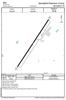


M91 - Springfield Robertson County
Located in Springfield, United States
ICAO - M91, IATA -
Data provided by AirmateGeneral information
Coordinates: N36°32'12" W86°55'16"
Elevation is 706 feet MSL.
Magnetic variation is -03° East View others Airports in Tennessee
Operational data
Special qualification required
Current time UTC:
Current local time:
Weather at : KJWN - John C Tune ( 39 km )
METAR: KJWN 300615Z AUTO 00000KT 10SM CLR M03/M04 A3030 RMK AO2
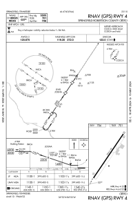
Communications frequencies: [VIEW]
Runways:
| RWY identifier | QFU | Length (ft) | Width (ft) | Surface | LDA (ft) |
| 04 | 34° | 5505 | 100 | ASPH | |
| 22 | 214° | 5505 | 100 | ASPH |
Airport contact information
Address: Springfield United States

