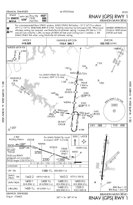
IAC chart of M54
Satellite view of M54
Sorry, we have no imagery here.
To navigate, press the arrow keys.
M54 - Lebanon Muni
Located in Lebanon, United States
ICAO - M54, IATA -
Data provided by
Airmate
General information
Coordinates:
N36°11'25" W86°18'56"
Elevation is
588 feet MSL.
Magnetic variation is
-02° East
Add your vote
Valid your vote
View others
Airports in
Tennessee
Operational data
Special qualification required
Current time UTC:
Current local time:
View NOTAMs / SUP AIP / TFR affecting this airport
[VIEW]
Communications frequencies:
[VIEW]
Runways:
RWY identifier
QFU
Length
(ft)
Width
(ft)
Surface
LDA
(ft)
01
7°
5000
100
ASPH
4527
19
187°
5000
100
ASPH
4527
04
46°
1801
150
GRASS
22
226°
1801
150
GRASS
Airport contact information
Address:
Lebanon United States
Other aviation service providers
Flight schools
WEB
Direct Flight Solutions
info@directflightsolutions.com
6154440031
Add your vote
Valid your vote
WEB
Lebanon Flying Club
Lebanon Flying Club
pilotandinsurancegeek@gmail.com
+1(615)479-9991
Add your vote
Valid your vote
WEB
Advanced Tailwheel Training
dillardrg@att.net
+1(636)236-5142
Add your vote
Valid your vote
WEB
Class Bravo Air
Class Bravo Air
fly@classbravoair.com
+1(615)669-5117
Add your vote
Valid your vote
Satellite view of M54
Sorry, we have no imagery here.
To navigate, press the arrow keys.
<<
BESbswy
BESbswy