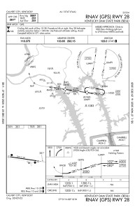
IAC chart of M34
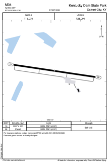
 ADC chart of M34
 Satellite view of M34
ADC chart of M34
Satellite view of M34
Sorry, we have no imagery here.
Sorry, we have no imagery here.
Sorry, we have no imagery here.
Sorry, we have no imagery here.
Sorry, we have no imagery here.
Sorry, we have no imagery here.


M34 - Kentucky Dam State Park
Located in Calvert City, United States
ICAO - M34, IATA -
Data provided by AirmateGeneral information
Coordinates: N37°0'35" W88°17'58"
Elevation is 351 feet MSL.
Magnetic variation is -03° East View others Airports in Kentucky
Operational data
Special qualification required
Current time UTC:
Current local time:
Weather at : KCEY - Kyle-Oakley Fld ( 39 km )
METAR: KCEY 020555Z AUTO 13007G14KT 10SM OVC047 18/07 A2980 RMK A01
Communications frequencies: [VIEW]
Runways:
| RWY identifier | QFU | Length (ft) | Width (ft) | Surface | LDA (ft) |
| 10 | 98° | 3997 | 100 | ASPH | |
| 28 | 278° | 3997 | 100 | ASPH |
Airport contact information
Address: Calvert City United States
Satellite view of M34
Sorry, we have no imagery here.
Sorry, we have no imagery here.
Sorry, we have no imagery here.
Sorry, we have no imagery here.
Sorry, we have no imagery here.
Sorry, we have no imagery here.