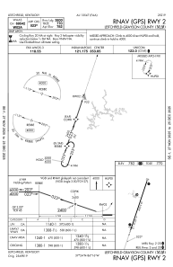
IAC chart of M20
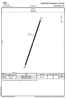
 ADC chart of M20
 Satellite view of M20
ADC chart of M20
Satellite view of M20
Sorry, we have no imagery here.
Sorry, we have no imagery here.
Sorry, we have no imagery here.
Sorry, we have no imagery here.
Sorry, we have no imagery here.
Sorry, we have no imagery here.


M20 - Leitchfield-Grayson County
Located in Leitchfield, United States
ICAO - M20, IATA -
Data provided by AirmateGeneral information
Coordinates: N37°23'59" W86°15'41"
Elevation is 782 feet MSL.
Magnetic variation is -04° East View others Airports in Kentucky
Operational data
Special qualification required
Current time UTC:
Current local time:
Weather at : KEKX - Addington Fld ( 43 km )
METAR: KEKX 020635Z AUTO 11003KT 10SM BKN050 10/04 A2991 RMK AO2 T00970040
Communications frequencies: [VIEW]
Runways:
| RWY identifier | QFU | Length (ft) | Width (ft) | Surface | LDA (ft) |
| 02 | 19° | 4000 | 60 | ASPH | 3800 |
| 20 | 199° | 4000 | 60 | ASPH |
Airport contact information
Address: Leitchfield United States
Satellite view of M20
Sorry, we have no imagery here.
Sorry, we have no imagery here.
Sorry, we have no imagery here.
Sorry, we have no imagery here.
Sorry, we have no imagery here.
Sorry, we have no imagery here.