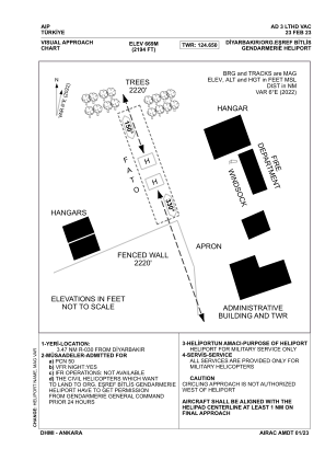
VAC chart of LTHD
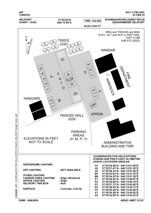
 ADC chart of LTHD
 Satellite view of LTHD
ADC chart of LTHD
Satellite view of LTHD
Sorry, we have no imagery here.
Sorry, we have no imagery here.
Sorry, we have no imagery here.
Sorry, we have no imagery here.
Sorry, we have no imagery here.
Sorry, we have no imagery here.


LTHD - Diyarbakir Orgeneral Esref Bitlis Gendarmerie Heliport
Located in Diyarbakir, Turkey
ICAO - , IATA -
Data provided by AirmateGeneral information
Coordinates: N37°55'36" E40°13'49"
Elevation is 2194 feet MSL.
Magnetic variation is 6.0° East View others Airports in Diyarbakir
Operational data
Special qualification required
Current time UTC:
Current local time:
Weather at : LTCC - Diyarbakir ( 5 km )
METAR: LTCC 221450Z 30007KT CAVOK 32/M03 Q1012 NOSIG RMK RWY16 28005KT 250V350 4CI200
TAF: TAF LTCC 221040Z 2212/2312 32007KT CAVOK BECMG 2308/2310 FEW040 BKN100
Communications frequencies: [VIEW]
Runways:
| RWY identifier | QFU | Length (ft) | Width (ft) | Surface | LDA (ft) |
| 15 | 0° | 689 | 164 | UNK | |
| 33 | 0° | 689 | 164 | UNK |
Airport contact information
Address: Diyarbakir Turkey
Satellite view of LTHD
Sorry, we have no imagery here.
Sorry, we have no imagery here.
Sorry, we have no imagery here.
Sorry, we have no imagery here.
Sorry, we have no imagery here.
Sorry, we have no imagery here.