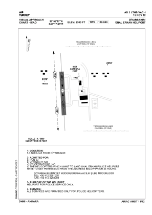
VAC chart of LTHB
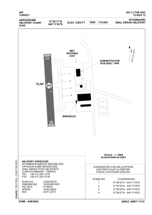
 ADC chart of LTHB
 Satellite view of LTHB
ADC chart of LTHB
Satellite view of LTHB
Sorry, we have no imagery here.
Sorry, we have no imagery here.
Sorry, we have no imagery here.
Sorry, we have no imagery here.
Sorry, we have no imagery here.
Sorry, we have no imagery here.


LTHB - Diyarbakir Unal Erkan Police Heliport
Located in Diyarbakir, Turkey
ICAO - , IATA -
Data provided by AirmateGeneral information
Coordinates: N37°56'17" E40°17'43"
Elevation is 2300 feet MSL.
Magnetic variation is 4.29° East View others Airports in Diyarbakir
Operational data
Special qualification required
Current time UTC:
Current local time:
Weather at : LTCC - Diyarbakir ( 10 km )
METAR: LTCC 230420Z 29003KT CAVOK 23/04 Q1011 NOSIG RMK RWY16 26005KT 250V310 5AC100
TAF: TAF LTCC 222240Z 2300/2324 30010KT CAVOK BECMG 2307/2309 FEW040 SCT100 BECMG 2315/2318 CAVOK
Communications frequencies: [VIEW]
Runways:
Airport contact information
Address: Diyarbakir Turkey
Satellite view of LTHB
Sorry, we have no imagery here.
Sorry, we have no imagery here.
Sorry, we have no imagery here.
Sorry, we have no imagery here.
Sorry, we have no imagery here.
Sorry, we have no imagery here.