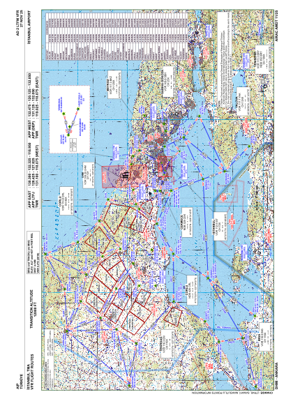
VAC chart of LTFM
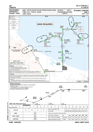
 IAC chart of LTFM
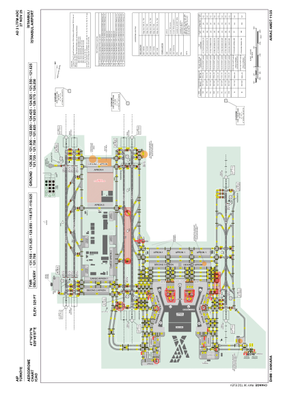
 ADC chart of LTFM
 Satellite view of LTFM
IAC chart of LTFMADC chart of LTFM
Satellite view of LTFM
Sorry, we have no imagery here.
Sorry, we have no imagery here.
Sorry, we have no imagery here.
Sorry, we have no imagery here.
Sorry, we have no imagery here.
Sorry, we have no imagery here.


LTFM - Istanbul
Located in Istanbul, Turkey
ICAO - , IATA - IST
Data provided by AirmateGeneral information
Coordinates: N41°16'31" E28°45'7"
Elevation is 325 feet MSL.
Magnetic variation is 5.4° East View others Airports in Istanbul
Operational data
Special qualification required
Current time UTC:
Current local time:
Weather
METAR: LTFM 291020Z 05026KT 9999 BKN024 12/04 Q1023 NOSIG RMK RWY17L 05020KT RWY34L 03022KT RWY16R 04022KT RWY36 04023KT RWY18 05021KT
TAF: TAF LTFM 290440Z 2906/3012 05023G35KT 9999 BKN022 BECMG 2915/2918 05018KT SCT025 BECMG 2922/2924 BKN022
Communications frequencies: [VIEW]
Runways:
| RWY identifier | QFU | Length (ft) | Width (ft) | Surface | LDA (ft) |
| 16R | 179° | 12303 | 197 | ASPH | 12303 |
| 34L | 359° | 12303 | 197 | ASPH | 12303 |
| 16L | 179° | 12303 | 148 | ASPH | 12303 |
| 34R | 359° | 12303 | 148 | ASPH | 12303 |
| 17L | 179° | 13451 | 197 | ASPH | 13451 |
| 35R | 359° | 13451 | 197 | ASPH | 13451 |
| 17R | 179° | 13451 | 148 | ASPH | 13451 |
| 35L | 359° | 13451 | 148 | ASPH | 13451 |
| 18 | 179° | 10039 | 148 | CONC+ASPH | 10039 |
| 36 | 359° | 10039 | 148 | CONC+ASPH | 10039 |
Airport contact information
Address: Istanbul Turkey
Satellite view of LTFM
Sorry, we have no imagery here.
Sorry, we have no imagery here.
Sorry, we have no imagery here.
Sorry, we have no imagery here.
Sorry, we have no imagery here.
Sorry, we have no imagery here.