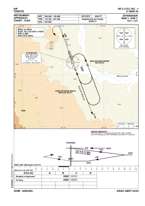
IAC chart of LTCC
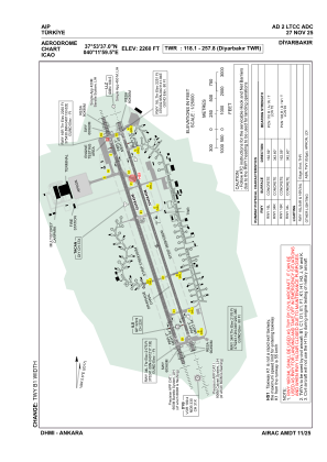
 ADC chart of LTCC
 Satellite view of LTCC
ADC chart of LTCC
Satellite view of LTCC
Sorry, we have no imagery here.
Sorry, we have no imagery here.
Sorry, we have no imagery here.
Sorry, we have no imagery here.
Sorry, we have no imagery here.
Sorry, we have no imagery here.


LTCC - Diyarbakir
Located in Diyarbakir, Turkey
ICAO - LTCC, IATA - DIY
Data provided by AirmateGeneral information
Coordinates: N37°53'37" E40°11'59"
Elevation is 2260 feet MSL.
Magnetic variation is 5.6° East View others Airports in Diyarbakir
Operational data
Special qualification required
Current time UTC:
Current local time:
Weather
METAR: LTCC 231620Z 30009KT 9999 FEW040 SCT100 30/02 Q1008 NOSIG RMK RWY16 32006KT 270V350 1CU040 3AC100
Communications frequencies: [VIEW]
Runways:
| RWY identifier | QFU | Length (ft) | Width (ft) | Surface | LDA (ft) |
| 16R | 163° | 11644 | 148 | CONC | 11644 |
| 34L | 343° | 11644 | 148 | CONC | 11644 |
| 16L | 163° | 11644 | 148 | CONC | 11644 |
| 34R | 343° | 11644 | 148 | CONC | 11644 |
Airport contact information
Address: Diyarbakir Turkey
Satellite view of LTCC
Sorry, we have no imagery here.
Sorry, we have no imagery here.
Sorry, we have no imagery here.
Sorry, we have no imagery here.
Sorry, we have no imagery here.
Sorry, we have no imagery here.