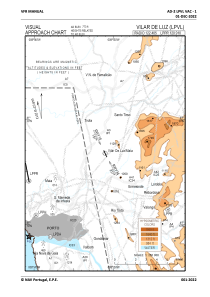
VAC chart of LPVL
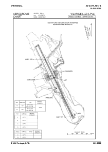
 ADC chart of LPVL
 Satellite view of LPVL
ADC chart of LPVL
Satellite view of LPVL
Sorry, we have no imagery here.
Sorry, we have no imagery here.
Sorry, we have no imagery here.
Sorry, we have no imagery here.
Sorry, we have no imagery here.
Sorry, we have no imagery here.


LPVL - Vilar De Luz/Maia
Located in Maia, Portugal
ICAO - LPVL, IATA -
Data provided by AirmateGeneral information
Coordinates: N41°16'46" W8°31'2"
Elevation is 773 feet MSL.
Magnetic variation is -002.9667° East View others Airports in Oporto District
Operational data
Special qualification required
Current time UTC:
Current local time:
Weather at : LPPR - Porto / Francisco Sa Carneiro ( 14 km )
METAR: LPPR 091430Z 32008KT 290V350 CAVOK 26/11 Q1013
TAF: TAF LPPR 091100Z 0912/1012 09008KT CAVOK BECMG 0912/0915 32008KT BECMG 0918/0920 VRB02KT BECMG 1000/1002 09010KT
Communications frequencies: [VIEW]
Runways:
| RWY identifier | QFU | Length (ft) | Width (ft) | Surface | LDA (ft) |
| 16 | 0° | 4295 | 95 | UNK | |
| 34 | 0° | 4295 | 95 | UNK |
Airport contact information
Address: Maia Portugal
Other aviation service providers
Flight schools

Aviation club (not for profit)

Satellite view of LPVL
Sorry, we have no imagery here.
Sorry, we have no imagery here.
Sorry, we have no imagery here.
Sorry, we have no imagery here.
Sorry, we have no imagery here.
Sorry, we have no imagery here.