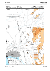
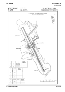


LPVL - Vilar De Luz/Maia
Located in Maia, Portugal
ICAO - LPVL, IATA -
Data provided by AirmateGeneral information
Coordinates: N41°16'46" W8°31'2"
Elevation is 773 feet MSL.
Magnetic variation is -002.9667° East View others Airports in Oporto District
Operational data
Special qualification required
Current time UTC:
Current local time:
Weather at : LPPR - Porto / Francisco Sa Carneiro ( 14 km )
METAR: LPPR 272330Z 35006KT CAVOK 11/10 Q1025
TAF: TAF LPPR 272300Z 2800/2824 VRB02KT CAVOK BECMG 2802/2804 08008KT BECMG 2813/2815 31010KT BECMG 2818/2820 VRB02KT
Communications frequencies: [VIEW]
Runways:
| RWY identifier | QFU | Length (ft) | Width (ft) | Surface | LDA (ft) |
| 16 | 0° | 4295 | 95 | UNK | |
| 34 | 0° | 4295 | 95 | UNK |
Airport contact information
Address: Maia Portugal

