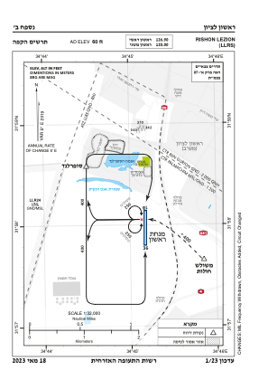
VAC chart of LLRS
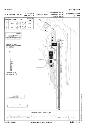
 ADC chart of LLRS
 Satellite view of LLRS
ADC chart of LLRS
Satellite view of LLRS
Sorry, we have no imagery here.
Sorry, we have no imagery here.
Sorry, we have no imagery here.
Sorry, we have no imagery here.
Sorry, we have no imagery here.
Sorry, we have no imagery here.


LLRS - Rishon Lezion
Located in ראשל"צ, Israel
ICAO - , IATA - RLZ
Data provided by AirmateGeneral information
Coordinates: N31°58'3" E34°45'13"
Elevation is 60 feet MSL.
Magnetic variation is 5° East View others Airports in Center District
Operational data
Special qualification required
Current time UTC:
Current local time:
Weather at : LLBG - Tel-Aviv/Ben-Gurion ( 13 km )
METAR: LLBG 062320Z VRB03KT CAVOK 19/16 Q1010 NOSIG
TAF: TAF LLBG 062306Z 0700/0724 VRB04KT 5000 BR SCT008 PROB40 TEMPO 0701/0705 1500 PRFG BKN003 BECMG 0707/0710 32012KT CAVOK BECMG 0714/0716 05005KT BECMG 0718/0720 VRB03KT TX27/0710Z TN14/0703Z
Communications frequencies: [VIEW]
Runways:
| RWY identifier | QFU | Length (ft) | Width (ft) | Surface | LDA (ft) |
| 18 | 0° | 2165 | 30 | UNK | |
| 33 | 0° | 2165 | 30 | UNK | |
| 36 | 0° | 0 | 0 | UNK | |
| 36 | 360° | 0 | 0 | UNK | |
| 18 | 180° | 0 | 0 | UNK |
Airport contact information
Address: ראשל"צ Israel
Satellite view of LLRS
Sorry, we have no imagery here.
Sorry, we have no imagery here.
Sorry, we have no imagery here.
Sorry, we have no imagery here.
Sorry, we have no imagery here.
Sorry, we have no imagery here.