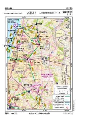
VAC chart of LLBL
 Satellite view of LLBL
Satellite view of LLBL
Sorry, we have no imagery here.
Sorry, we have no imagery here.
Sorry, we have no imagery here.
Sorry, we have no imagery here.
Sorry, we have no imagery here.
Sorry, we have no imagery here.


LLBL - Beilinson Hospital
Located in פ"ת, Israel
ICAO - , IATA -
Data provided by AirmateGeneral information
Coordinates: N32°5'13" E34°51'54"
Elevation is 114 feet MSL.
Magnetic variation is 5° East View others Airports in Tel Aviv District
Operational data
Special qualification required
Current time UTC:
Current local time:
Weather at : LLBG - Tel-Aviv/Ben-Gurion ( 9 km )
METAR: LLBG 101120Z 29016KT 9999 BKN050 20/08 Q1015 NOSIG
TAF: TAF LLBG 101104Z 1012/1112 29016KT 9999 SCT035 TEMPO 1012/1015 BKN030 BECMG 1015/1017 26006KT SCT030 TEMPO 1017/1107 VRB04KT BKN025 BECMG 1107/1109 27012KT PROB40 TEMPO 1109/1112 -RA BKN025 TX19/1012Z TN14/1103Z
Communications frequencies: [VIEW]
Runways:
Airport contact information
Address: פ"ת Israel
Satellite view of LLBL
Sorry, we have no imagery here.
Sorry, we have no imagery here.
Sorry, we have no imagery here.
Sorry, we have no imagery here.
Sorry, we have no imagery here.
Sorry, we have no imagery here.