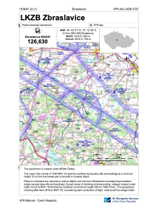
VAC chart of LKZB
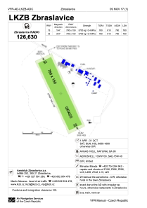
 ADC chart of LKZB
 Satellite view of LKZB
ADC chart of LKZB
Satellite view of LKZB
Sorry, we have no imagery here.
Sorry, we have no imagery here.
Sorry, we have no imagery here.
Sorry, we have no imagery here.
Sorry, we have no imagery here.
Sorry, we have no imagery here.


LKZB - Zbraslavice
Located in Zbraslavice, Czech Republic
ICAO - LKZB, IATA -
Data provided by AirmateGeneral information
Coordinates: N49°48'51" E15°12'6"
Elevation is 1618 feet MSL.
View others Airports in Central Bohemian Region
Operational data
Special qualification required
Current time UTC:
Current local time:
Weather at : LKCV - Caslav ( 19 km )
METAR: LKCV 092300Z 27010KT CAVOK 10/00 Q1019 NOSIG RMK BLU BLU
TAF: TAF LKCV 091700Z 0918/1018 30008KT CAVOK BECMG 1000/1002 31012KT TEMPO 1002/1008 BKN030 TEMPO 1006/1016 32016KT
Communications frequencies: [VIEW]
Runways:
| RWY identifier | QFU | Length (ft) | Width (ft) | Surface | LDA (ft) |
| 15 | 0° | 2559 | 492 | UNK | |
| 33 | 0° | 2559 | 492 | UNK |
Airport contact information
Address: Zbraslavice Czech Republic
Other aviation service providers
Aviation club (not for profit)

Satellite view of LKZB
Sorry, we have no imagery here.
Sorry, we have no imagery here.
Sorry, we have no imagery here.
Sorry, we have no imagery here.
Sorry, we have no imagery here.
Sorry, we have no imagery here.