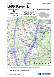
VAC chart of LKRK
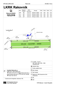
 ADC chart of LKRK
 Satellite view of LKRK
ADC chart of LKRK
Satellite view of LKRK
Sorry, we have no imagery here.
Sorry, we have no imagery here.
Sorry, we have no imagery here.
Sorry, we have no imagery here.
Sorry, we have no imagery here.


LKRK - Rakovnik
Located in Rakovnik, Czech Republic
ICAO - LKRK, IATA -
Data provided by AirmateGeneral information
Coordinates: N50°5'39" E13°41'20"
Elevation is 1273 feet MSL.
View others Airports in Central Bohemian Region
Operational data
Special qualification required
Current time UTC:
Current local time:
Weather at : LKPR - Praha/Ruzyne ( 41 km )
METAR: LKPR 112130Z 20005KT CAVOK 06/04 Q1017 NOSIG
TAF: TAF LKPR 112000Z 1121/1303 34007KT 9999 SCT040 TEMPO 1123/1210 26005KT BKN030 BECMG 1210/1212 19005KT BECMG 1212/1214 10004KT CAVOK
Communications frequencies: [VIEW]
Runways:
| RWY identifier | QFU | Length (ft) | Width (ft) | Surface | LDA (ft) |
| 09L | 0° | 2986 | 66 | UNK | |
| 27R | 0° | 2986 | 66 | UNK | |
| 09R | 0° | 2986 | 66 | UNK | |
| 27L | 0° | 2986 | 66 | UNK |
Airport contact information
Address: Rakovnik Czech Republic
Satellite view of LKRK
Sorry, we have no imagery here.
Sorry, we have no imagery here.
Sorry, we have no imagery here.
Sorry, we have no imagery here.
Sorry, we have no imagery here.