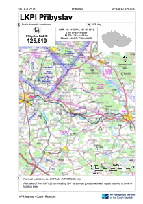
VAC chart of LKPI
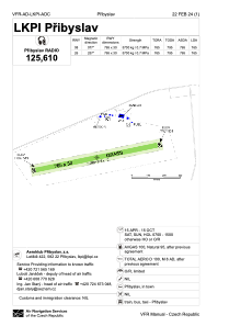
 ADC chart of LKPI
 Satellite view of LKPI

ADC chart of LKPI
Satellite view of LKPI
Sorry, we have no imagery here.
Sorry, we have no imagery here.
Sorry, we have no imagery here.
Sorry, we have no imagery here.
Sorry, we have no imagery here.
Sorry, we have no imagery here.


LKPI - Pribyslav
Located in Pribyslav, Czech Republic
ICAO - LKPI, IATA -
Data provided by AirmateGeneral information
Coordinates: N49°34'51" E15°45'46"
Elevation is 1742 feet MSL.
View others Airports in Vysocina Region
Operational data
Special qualification required
Current time UTC:
Current local time:
Weather at : LKPD - Pardubice ( 48 km )
METAR: LKPD 190430Z 00000KT CAVOK M06/M08 Q1030 RMK BLACK
Communications frequencies: [VIEW]
Runways:
| RWY identifier | QFU | Length (ft) | Width (ft) | Surface | LDA (ft) |
| 08 | 0° | 2510 | 98 | UNK | |
| 26 | 0° | 2510 | 98 | UNK |
Airport contact information
Address: Pribyslav Czech Republic
Satellite view of LKPI
Sorry, we have no imagery here.
Sorry, we have no imagery here.
Sorry, we have no imagery here.
Sorry, we have no imagery here.
Sorry, we have no imagery here.
Sorry, we have no imagery here.