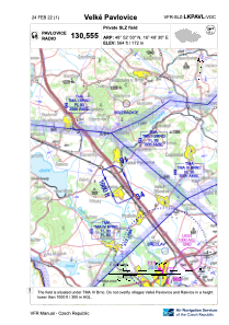
VAC chart of LKPAVL
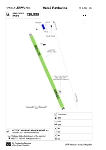
 ADC chart of LKPAVL
 Satellite view of LKPAVL
ADC chart of LKPAVL
Satellite view of LKPAVL
Sorry, we have no imagery here.
Sorry, we have no imagery here.
Sorry, we have no imagery here.
Sorry, we have no imagery here.
Sorry, we have no imagery here.
Sorry, we have no imagery here.


LKPAVL - Velké Pavlovice
Located in Velké Pavlovice, Czech Republic
ICAO - , IATA -
Data provided by AirmateGeneral information
Coordinates: N48°52'50" E16°49'29"
Elevation is 564 feet MSL.
Magnetic variation is 4° East View others Airports in South Moravian Region
Operational data
Special qualification required
Current time UTC:
Current local time:
Weather at : LKTB - Brno/Turany ( 32 km )
METAR: LKTB 100330Z 33014KT 9999 SCT041 10/00 Q1017 NOSIG
TAF: TAF LKTB 092300Z 1000/1024 27006KT CAVOK TEMPO 1004/1018 33012KT 9999 BKN030
Communications frequencies: [VIEW]
Runways:
| RWY identifier | QFU | Length (ft) | Width (ft) | Surface | LDA (ft) |
| 16 | 155° | 1969 | 82 | GRASS | 1969 |
| 34 | 335° | 1969 | 82 | GRASS | 1969 |
Airport contact information
Address: Velké Pavlovice Czech Republic
Satellite view of LKPAVL
Sorry, we have no imagery here.
Sorry, we have no imagery here.
Sorry, we have no imagery here.
Sorry, we have no imagery here.
Sorry, we have no imagery here.
Sorry, we have no imagery here.