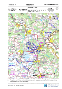
VAC chart of LKNACH
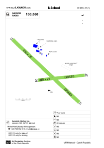
 ADC chart of LKNACH
 Satellite view of LKNACH

ADC chart of LKNACH
Satellite view of LKNACH
Sorry, we have no imagery here.
Sorry, we have no imagery here.
Sorry, we have no imagery here.
Sorry, we have no imagery here.
Sorry, we have no imagery here.
Sorry, we have no imagery here.


LKNACH - Nachod
Located in Náchod, Czech Republic
ICAO - , IATA -
Data provided by AirmateGeneral information
Coordinates: N50°24'47" E16°7'18"
Elevation is 1443 feet MSL.
View others Airports in Hradec Králové Region
Operational data
Special qualification required
Current time UTC:
Current local time:
Communications frequencies: [VIEW]
Runways:
| RWY identifier | QFU | Length (ft) | Width (ft) | Surface | LDA (ft) |
| 09 | 84° | 1181 | 72 | GRASS | 1181 |
| 27 | 264° | 1181 | 72 | GRASS | 1181 |
| 13 | 134° | 2067 | 82 | GRASS | |
| 31 | 314° | 2067 | 82 | GRASS | 2067 |
Airport contact information
Address: Náchod Czech Republic
Satellite view of LKNACH
Sorry, we have no imagery here.
Sorry, we have no imagery here.
Sorry, we have no imagery here.
Sorry, we have no imagery here.
Sorry, we have no imagery here.
Sorry, we have no imagery here.