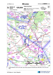
VAC chart of LKMIRO
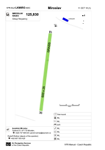
 ADC chart of LKMIRO
 Satellite view of LKMIRO
ADC chart of LKMIRO
Satellite view of LKMIRO
Sorry, we have no imagery here.
Sorry, we have no imagery here.
Sorry, we have no imagery here.
Sorry, we have no imagery here.
Sorry, we have no imagery here.
Sorry, we have no imagery here.


LKMIRO - Miroslav
Located in Miroslav, Czech Republic
ICAO - , IATA -
Data provided by AirmateGeneral information
Coordinates: N48°55'53" E16°17'55"
Elevation is 780 feet MSL.
View others Airports in South Moravian Region
Operational data
Special qualification required
Current time UTC:
Current local time:
Weather at : LKNA - Namest ( 29 km )
METAR: LKNA 101500Z 30020G30KT 9999 BKN045 08/M01 Q1020 NOSIG
TAF: TAF LKNA 101100Z 1012/1112 30012KT CAVOK TEMPO 1012/1018 34014G24KT BKN035 TEMPO 1108/1112 32018G28KT
Communications frequencies: [VIEW]
Runways:
| RWY identifier | QFU | Length (ft) | Width (ft) | Surface | LDA (ft) |
| 18 | 9° | 1969 | 82 | GRASS | 1969 |
| 36 | 189° | 1969 | 82 | GRASS | 1969 |
Airport contact information
Address: Miroslav Czech Republic
Satellite view of LKMIRO
Sorry, we have no imagery here.
Sorry, we have no imagery here.
Sorry, we have no imagery here.
Sorry, we have no imagery here.
Sorry, we have no imagery here.
Sorry, we have no imagery here.