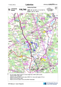
VAC chart of LKLETO
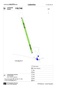
 ADC chart of LKLETO
 Satellite view of LKLETO
ADC chart of LKLETO
Satellite view of LKLETO
Sorry, we have no imagery here.
Sorry, we have no imagery here.
Sorry, we have no imagery here.
Sorry, we have no imagery here.
Sorry, we have no imagery here.
Sorry, we have no imagery here.


LKLETO - Letovice
Located in 1,7 Km E Letovice, Czech Republic
ICAO - , IATA -
Data provided by AirmateGeneral information
Coordinates: N49°32'48" E16°35'55"
Elevation is 1247 feet MSL.
View others Airports in South Moravian Region
Operational data
Special qualification required
Current time UTC:
Current local time:
Weather at : LKTB - Brno/Turany ( 44 km )
METAR: LKTB 091300Z 29009KT 260V320 CAVOK 13/M07 Q1019 NOSIG
TAF: TAF LKTB 091100Z 0912/1012 32010KT CAVOK BECMG 1001/1003 9999 BKN030 PROB40 TEMPO 1003/1011 9999 -SHRA BKN023
Communications frequencies: [VIEW]
Runways:
| RWY identifier | QFU | Length (ft) | Width (ft) | Surface | LDA (ft) |
| 16 | 165° | 1493 | 66 | GRASS | 1493 |
| 34 | 345° | 1493 | 66 | GRASS | 1493 |
Airport contact information
Address: 1,7 Km E Letovice Czech Republic
Satellite view of LKLETO
Sorry, we have no imagery here.
Sorry, we have no imagery here.
Sorry, we have no imagery here.
Sorry, we have no imagery here.
Sorry, we have no imagery here.
Sorry, we have no imagery here.