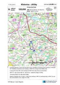
VAC chart of LKJIRI
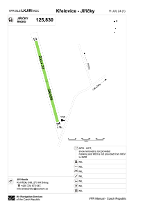
 ADC chart of LKJIRI
 Satellite view of LKJIRI

ADC chart of LKJIRI
Satellite view of LKJIRI
Sorry, we have no imagery here.
Sorry, we have no imagery here.
Sorry, we have no imagery here.
Sorry, we have no imagery here.
Sorry, we have no imagery here.
Sorry, we have no imagery here.


LKJIRI - Krelovice - Jiricky
Located in Pelhřimov, Czech Republic
ICAO - , IATA -
Data provided by AirmateGeneral information
Coordinates: N49°33'8" E15°9'20"
Elevation is 1683 feet MSL.
View others Airports in Vysocina Region
Operational data
Special qualification required
Current time UTC:
Current local time:
Weather at : LKCV - Caslav ( 46 km )
METAR: LKCV 190800Z VRB02KT CAVOK 04/M07 Q1031 NOSIG RMK BLU BLU
TAF: TAF LKCV 190500Z 1906/2006 15005KT CAVOK TEMPO 1912/1918 14010KT
Communications frequencies: [VIEW]
Runways:
| RWY identifier | QFU | Length (ft) | Width (ft) | Surface | LDA (ft) |
| 16 | 168° | 1969 | 66 | GRASS | 1969 |
| 34 | 348° | 1969 | 66 | GRASS | 1969 |
Airport contact information
Address: Pelhřimov Czech Republic
Satellite view of LKJIRI
Sorry, we have no imagery here.
Sorry, we have no imagery here.
Sorry, we have no imagery here.
Sorry, we have no imagery here.
Sorry, we have no imagery here.
Sorry, we have no imagery here.