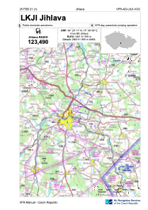
VAC chart of LKJI
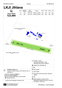
 ADC chart of LKJI
 Satellite view of LKJI

ADC chart of LKJI
Satellite view of LKJI
Sorry, we have no imagery here.
Sorry, we have no imagery here.
Sorry, we have no imagery here.
Sorry, we have no imagery here.
Sorry, we have no imagery here.
Sorry, we have no imagery here.


LKJI - Jihlava
Located in Jihlava, Czech Republic
ICAO - LKJI, IATA -
Data provided by AirmateGeneral information
Coordinates: N49°25'11" E15°38'8"
Elevation is 1821 feet MSL.
View others Airports in Vysocina Region
Operational data
Special qualification required
Current time UTC:
Current local time:
Weather at : LKNA - Namest ( 45 km )
METAR: LKNA 190530Z 10004KT CAVOK M03/M09 Q1029 NOSIG RMK BLU BLU
TAF: TAF LKNA 182300Z 1900/2000 VRB02KT CAVOK TEMPO 1900/1905 17005KT BECMG 1905/1907 11007KT TEMPO 1909/1917 14012KT
Communications frequencies: [VIEW]
Runways:
| RWY identifier | QFU | Length (ft) | Width (ft) | Surface | LDA (ft) |
| 10 | 0° | 3018 | 328 | Grass | |
| 28 | 0° | 3018 | 328 | Grass |
Airport contact information
Address: Jihlava Czech Republic
Other aviation service providers
Flight schools

Air Jihlava - Service S.R.O.
Air Jihlava - Service S.R.O.
info@airjihlava.cz+420567221922
+420602760578
+420602760578
Satellite view of LKJI
Sorry, we have no imagery here.
Sorry, we have no imagery here.
Sorry, we have no imagery here.
Sorry, we have no imagery here.
Sorry, we have no imagery here.
Sorry, we have no imagery here.