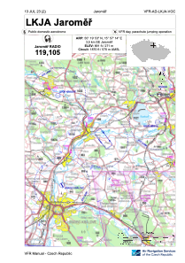
VAC chart of LKJA
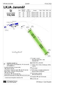
 ADC chart of LKJA
 Satellite view of LKJA

ADC chart of LKJA
Satellite view of LKJA
Sorry, we have no imagery here.
Sorry, we have no imagery here.
Sorry, we have no imagery here.
Sorry, we have no imagery here.
Sorry, we have no imagery here.
Sorry, we have no imagery here.


LKJA - Jaromer
Located in Jaromer, Czech Republic
ICAO - LKJA, IATA -
Data provided by AirmateGeneral information
Coordinates: N50°19'53" E15°57'14"
Elevation is 891 feet MSL.
View others Airports in Hradec Králové Region
Operational data
Special qualification required
Current time UTC:
Current local time:
Weather at : LKPD - Pardubice ( 39 km )
METAR: LKPD 181700Z VRB02KT CAVOK 05/M12 Q1030 RMK BLACK
Communications frequencies: [VIEW]
Runways:
| RWY identifier | QFU | Length (ft) | Width (ft) | Surface | LDA (ft) |
| 14R | 0° | 3084 | 131 | UNK | |
| 32L | 0° | 3084 | 131 | UNK | |
| 14L | 0° | 3084 | 164 | UNK | |
| 32R | 0° | 3084 | 164 | UNK |
Airport contact information
Address: Jaromer Czech Republic
Other aviation service providers
Flight schools

Aviation club (not for profit)

Satellite view of LKJA
Sorry, we have no imagery here.
Sorry, we have no imagery here.
Sorry, we have no imagery here.
Sorry, we have no imagery here.
Sorry, we have no imagery here.
Sorry, we have no imagery here.