VAC chart of LKHATH
 ADC chart of LKHATH
 Satellite view of LKHATH
ADC chart of LKHATH
Satellite view of LKHATH
Sorry, we have no imagery here.
Sorry, we have no imagery here.
Sorry, we have no imagery here.
Sorry, we have no imagery here.
Sorry, we have no imagery here.
Sorry, we have no imagery here.


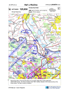
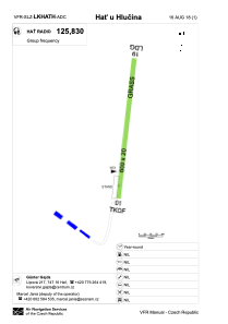
LKHATH - Hat U Hlucina
Located in Hlučín, Czech Republic
ICAO - , IATA -
Data provided by AirmateGeneral information
Coordinates: N49°57'0" E18°15'53"
Elevation is 774 feet MSL.
View others Airports in Moravian-Silesian Region
Operational data
Special qualification required
Current time UTC:
Current local time:
Weather at : LKMT - Ostrava/Mosnov ( 30 km )
METAR: LKMT 290100Z 00000KT CAVOK 08/06 Q1007 NOSIG
TAF: TAF LKMT 282300Z 2900/2924 02005KT CAVOK PROB30 TEMPO 2903/2908 7000 BKN018 TEMPO 2910/2920 36012KT 9999 BKN040
Communications frequencies: [VIEW]
Runways:
| RWY identifier | QFU | Length (ft) | Width (ft) | Surface | LDA (ft) |
| 01 | 9° | 1969 | 66 | GRASS | |
| 19 | 189° | 1969 | 66 | GRASS | 1969 |
Airport contact information
Address: Hlučín Czech Republic
Satellite view of LKHATH
Sorry, we have no imagery here.
Sorry, we have no imagery here.
Sorry, we have no imagery here.
Sorry, we have no imagery here.
Sorry, we have no imagery here.
Sorry, we have no imagery here.