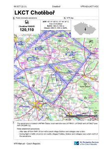
VAC chart of LKCT
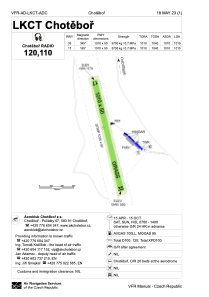
 ADC chart of LKCT
 Satellite view of LKCT

ADC chart of LKCT
Satellite view of LKCT
Sorry, we have no imagery here.
Sorry, we have no imagery here.
Sorry, we have no imagery here.
Sorry, we have no imagery here.
Sorry, we have no imagery here.
Sorry, we have no imagery here.


LKCT - Chotebor
Located in Chotebor, Czech Republic
ICAO - LKCT, IATA -
Data provided by AirmateGeneral information
Coordinates: N49°41'9" E15°40'34"
Elevation is 1946 feet MSL.
View others Airports in Vysocina Region
Operational data
Special qualification required
Current time UTC:
Current local time:
Weather at : LKCV - Caslav ( 35 km )
TAF: TAF LKCV 182300Z 1900/2000 15004KT CAVOK TEMPO 1912/1918 14009KT
Communications frequencies: [VIEW]
Runways:
| RWY identifier | QFU | Length (ft) | Width (ft) | Surface | LDA (ft) |
| 17 | 0° | 3314 | 164 | UNK | |
| 35 | 0° | 3314 | 164 | UNK |
Airport contact information
Address: Chotebor Czech Republic
Satellite view of LKCT
Sorry, we have no imagery here.
Sorry, we have no imagery here.
Sorry, we have no imagery here.
Sorry, we have no imagery here.
Sorry, we have no imagery here.
Sorry, we have no imagery here.