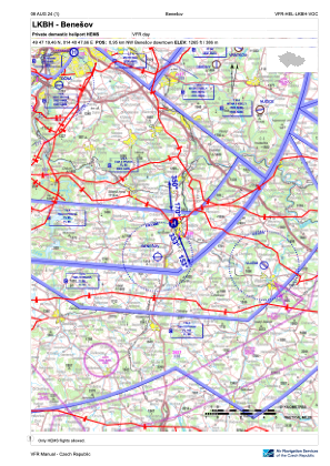
VAC chart of LKBH
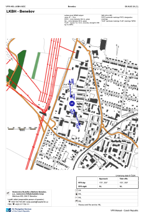
 ADC chart of LKBH
 Satellite view of LKBH
ADC chart of LKBH
Satellite view of LKBH
Sorry, we have no imagery here.
Sorry, we have no imagery here.
Sorry, we have no imagery here.
Sorry, we have no imagery here.
Sorry, we have no imagery here.
Sorry, we have no imagery here.


LKBH - Benesov
Located in Benesov, Czech Republic
ICAO - , IATA -
Data provided by AirmateGeneral information
Coordinates: N49°47'19" E14°40'48"
Elevation is 1265 feet MSL.
View others Airports in Central Bohemian Region
Operational data
Special qualification required
Current time UTC:
Current local time:
Weather at : LKKB - Kbely ( 38 km )
METAR: LKKB 122300Z 15004KT 130V190 CAVOK 12/04 Q1010
TAF: TAF LKKB 121700Z 1218/1318 09010KT CAVOK BECMG 1304/1306 15006KT BECMG 1312/1314 VRB02KT PROB40 TEMPO 1316/1318 8000 SHRA SCT040TCU
Communications frequencies: [VIEW]
Runways:
Airport contact information
Address: Benesov Czech Republic
Satellite view of LKBH
Sorry, we have no imagery here.
Sorry, we have no imagery here.
Sorry, we have no imagery here.
Sorry, we have no imagery here.
Sorry, we have no imagery here.
Sorry, we have no imagery here.