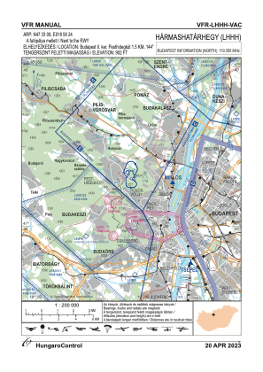
VAC chart of LHHH
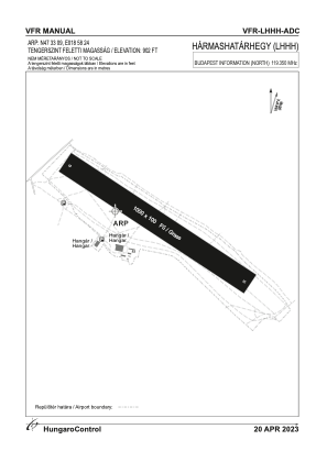
 ADC chart of LHHH
 Satellite view of LHHH
ADC chart of LHHH
Satellite view of LHHH
Sorry, we have no imagery here.
Sorry, we have no imagery here.
Sorry, we have no imagery here.
Sorry, we have no imagery here.
Sorry, we have no imagery here.
Sorry, we have no imagery here.


LHHH - Harmashatarhegy
Located in Budapest, Hungary
ICAO - LHHH, IATA -
Data provided by AirmateGeneral information
Coordinates: N47°33'1" E18°58'24"
Elevation is 902 feet MSL.
Magnetic variation is 5° East View others Airports in Budapest
Operational data
Special qualification required
Current time UTC:
Current local time:
Weather at : LHBP - Budapest/Liszt Ferenc International Airport ( 25 km )
METAR: LHBP 091530Z 29012KT CAVOK 14/M04 Q1017 NOSIG
TAF: TAF LHBP 091115Z 0912/1012 31010KT CAVOK BECMG 0917/0920 27004KT BECMG 1001/1004 30014KT TEMPO 1003/1012 -RA -SHRA SCT035 BKN070 BECMG 1005/1008 33020G32KT
Communications frequencies: [VIEW]
Runways:
| RWY identifier | QFU | Length (ft) | Width (ft) | Surface | LDA (ft) |
| 13 | 0° | 3281 | 328 | GRASS | |
| 31 | 0° | 3281 | 328 | GRASS |
Airport contact information
Address: Budapest Hungary
Satellite view of LHHH
Sorry, we have no imagery here.
Sorry, we have no imagery here.
Sorry, we have no imagery here.
Sorry, we have no imagery here.
Sorry, we have no imagery here.
Sorry, we have no imagery here.