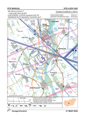
VAC chart of LHDV
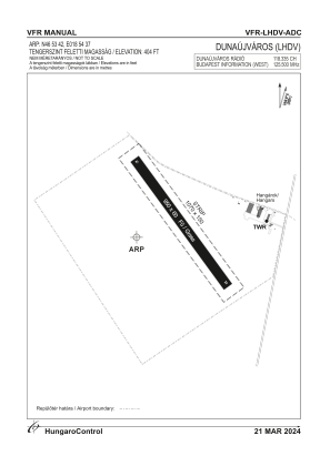
 ADC chart of LHDV
 Satellite view of LHDV
ADC chart of LHDV
Satellite view of LHDV
Sorry, we have no imagery here.
Sorry, we have no imagery here.
Sorry, we have no imagery here.
Sorry, we have no imagery here.
Sorry, we have no imagery here.
Sorry, we have no imagery here.


LHDV - Dunaujvaros
Located in Dunaujvaros, Hungary
ICAO - LHDV, IATA -
Data provided by AirmateGeneral information
Coordinates: N46°53'42" E18°54'37"
Elevation is 404 feet MSL.
Magnetic variation is 3.7° East View others Airports in Fejér
Operational data
Special qualification required
Current time UTC:
Current local time:
Weather at : LHKE - Kecskemet ( 64 km )
METAR: LHKE 250715Z 29008KT 250V320 CAVOK 25/17 Q1013 NOSIG RMK BLU
TAF: TAF LHKE 250515Z 2506/2515 31008KT CAVOK BECMG 2510/2512 28010KT
Communications frequencies: [VIEW]
Runways:
| RWY identifier | QFU | Length (ft) | Width (ft) | Surface | LDA (ft) |
| 14 | 0° | 3117 | 197 | GRASS | |
| 32 | 0° | 3117 | 197 | GRASS |
Airport contact information
Address: Dunaujvaros Hungary
Satellite view of LHDV
Sorry, we have no imagery here.
Sorry, we have no imagery here.
Sorry, we have no imagery here.
Sorry, we have no imagery here.
Sorry, we have no imagery here.
Sorry, we have no imagery here.