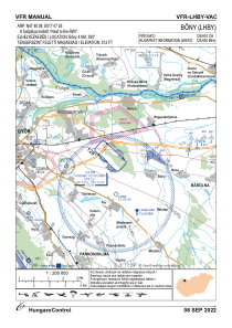
VAC chart of LHBY
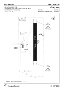
 ADC chart of LHBY
 Satellite view of LHBY
ADC chart of LHBY
Satellite view of LHBY
Sorry, we have no imagery here.
Sorry, we have no imagery here.
Sorry, we have no imagery here.
Sorry, we have no imagery here.
Sorry, we have no imagery here.
Sorry, we have no imagery here.


LHBY - Bony
Located in Bony, Hungary
ICAO - , IATA -
Data provided by AirmateGeneral information
Coordinates: N47°40'8" E17°47'5"
Elevation is 512 feet MSL.
View others Airports in Gyor-Moson-Sopron
Operational data
Special qualification required
Current time UTC:
Current local time:
Weather at : LHPR - Gyor/Per ( 5 km )
METAR: LHPR 131145Z AUTO VRB05KT CAVOK 33/11 Q1019
Communications frequencies: [VIEW]
Runways:
| RWY identifier | QFU | Length (ft) | Width (ft) | Surface | LDA (ft) |
| 13 | 0° | 2133 | 197 | GRASS | |
| 31 | 0° | 2133 | 197 | GRASS |
Airport contact information
Address: Bony Hungary
Satellite view of LHBY
Sorry, we have no imagery here.
Sorry, we have no imagery here.
Sorry, we have no imagery here.
Sorry, we have no imagery here.
Sorry, we have no imagery here.
Sorry, we have no imagery here.