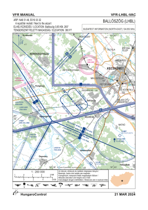
VAC chart of LHBL
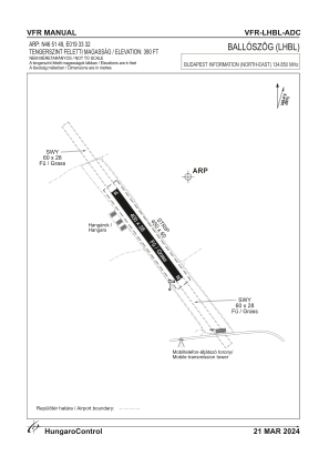
 ADC chart of LHBL
 Satellite view of LHBL
ADC chart of LHBL
Satellite view of LHBL
Sorry, we have no imagery here.
Sorry, we have no imagery here.
Sorry, we have no imagery here.
Sorry, we have no imagery here.
Sorry, we have no imagery here.
Sorry, we have no imagery here.


LHBL - Balloszog
Located in Balloszog, Hungary
ICAO - , IATA -
Data provided by AirmateGeneral information
Coordinates: N46°51'49" E19°33'32"
Elevation is 390 feet MSL.
Magnetic variation is 5° East View others Airports in Bács-Kiskun
Operational data
Special qualification required
Current time UTC:
Current local time:
Weather at : LHKE - Kecskemet ( 16 km )
METAR: LHKE 102345Z 21006KT CAVOK 04/M08 Q1020 NOSIG RMK BLU
TAF: TAF LHKE 102015Z 1021/1106 VRB02KT CAVOK BECMG 1021/1024 24005KT BECMG 1103/1106 26010KT
Communications frequencies: [VIEW]
Runways:
| RWY identifier | QFU | Length (ft) | Width (ft) | Surface | LDA (ft) |
| 14 | 144° | 1061 | 74 | GRASS | |
| 32 | 324° | 1061 | 74 | GRASS |
Airport contact information
Address: Balloszog Hungary
Satellite view of LHBL
Sorry, we have no imagery here.
Sorry, we have no imagery here.
Sorry, we have no imagery here.
Sorry, we have no imagery here.
Sorry, we have no imagery here.
Sorry, we have no imagery here.