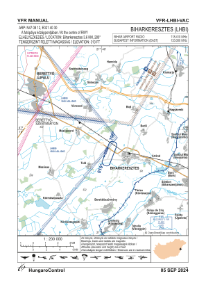
VAC chart of LHBI
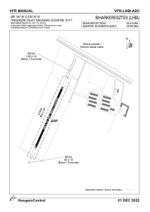
 ADC chart of LHBI
 Satellite view of LHBI
ADC chart of LHBI
Satellite view of LHBI
Sorry, we have no imagery here.
Sorry, we have no imagery here.
Sorry, we have no imagery here.
Sorry, we have no imagery here.
Sorry, we have no imagery here.
Sorry, we have no imagery here.


LHBI - Bihar Airport
Located in Biharkeresztes, Hungary
ICAO - , IATA -
Data provided by AirmateGeneral information
Coordinates: N47°8'12" E21°40'30"
Elevation is 313 feet MSL.
View others Airports in Hajdu-Bihar
Operational data
Special qualification required
Current time UTC:
Current local time:
Weather at : LROD - Oradea ( 21 km )
METAR: LROD 111700Z 05012KT CAVOK 10/03 Q1009
TAF: TAF LROD 111400Z 1115/1124 16010KT CAVOK BECMG 1116/1118 06010KT TEMPO 1117/1122 5000 -RA BR BKN015 BKN040
Communications frequencies: [VIEW]
Runways:
| RWY identifier | QFU | Length (ft) | Width (ft) | Surface | LDA (ft) |
| 02 | 0° | 2133 | 59 | CONC | |
| 20 | 0° | 2133 | 59 | CONC |
Airport contact information
Address: Biharkeresztes Hungary
Satellite view of LHBI
Sorry, we have no imagery here.
Sorry, we have no imagery here.
Sorry, we have no imagery here.
Sorry, we have no imagery here.
Sorry, we have no imagery here.
Sorry, we have no imagery here.