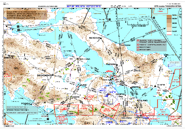
VAC chart of LGTG
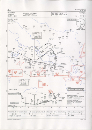
 IAC chart of LGTG
 Satellite view of LGTG
IAC chart of LGTG
Satellite view of LGTG
Sorry, we have no imagery here.
Sorry, we have no imagery here.
Sorry, we have no imagery here.
Sorry, we have no imagery here.
Sorry, we have no imagery here.
Sorry, we have no imagery here.


LGTG - Tanagra
Located in Chalkis, Greece
ICAO - LGTG, IATA -
Data provided by AirmateGeneral information
Coordinates: N38°20'23" E23°33'53"
Elevation is 495 feet MSL.
View others Airports in Boeotia
Operational data
Special qualification required
Current time UTC:
Current local time:
Weather
TAF: TAF LGTG 110800Z 1109/1118 35010KT 9999 FEW025
Communications frequencies: [VIEW]
Runways:
| RWY identifier | QFU | Length (ft) | Width (ft) | Surface | LDA (ft) |
| 10C | 102° | 9810 | 148 | UNK | |
| 28C | 282° | 9810 | 148 | UNK |
Airport contact information
Address: Chalkis Greece
Satellite view of LGTG
Sorry, we have no imagery here.
Sorry, we have no imagery here.
Sorry, we have no imagery here.
Sorry, we have no imagery here.
Sorry, we have no imagery here.
Sorry, we have no imagery here.