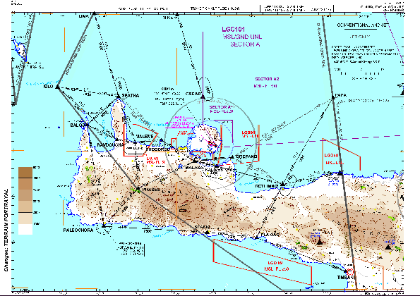
VAC chart of LGSA
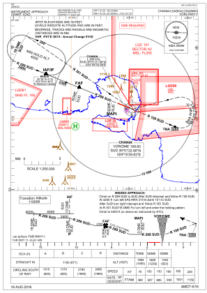
 IAC chart of LGSA
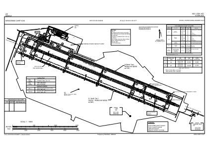
 ADC chart of LGSA
 Satellite view of LGSA
IAC chart of LGSAADC chart of LGSA
Satellite view of LGSA
Sorry, we have no imagery here.
Sorry, we have no imagery here.
Sorry, we have no imagery here.
Sorry, we have no imagery here.
Sorry, we have no imagery here.
Sorry, we have no imagery here.


LGSA - Chania / Ioannis Daskalogiannis
Located in Chania, Greece
ICAO - LGSA, IATA - CHQ
Data provided by AirmateGeneral information
Coordinates: N35°31'53" E24°9'4"
Elevation is 490 feet MSL.
View others Airports in Chania
Operational data
Special qualification required
Current time UTC:
Current local time:
Weather
METAR: LGSA 231750Z 28006KT CAVOK 15/11 Q1024
TAF: TAF LGSA 231700Z 2318/2418 VRB03KT 9999 FEW020 TEMPO 2400/2402 FEW020 BKN080
Communications frequencies: [VIEW]
Runways:
| RWY identifier | QFU | Length (ft) | Width (ft) | Surface | LDA (ft) |
| 11L | 112° | 10984 | 148 | UNK | |
| 29R | 292° | 10984 | 148 | UNK | |
| 11R | 112° | 11010 | 93 | UNK | |
| 29L | 292° | 11010 | 93 | UNK |
Airport contact information
Address: Chania Greece

Satellite view of LGSA
Sorry, we have no imagery here.
Sorry, we have no imagery here.
Sorry, we have no imagery here.
Sorry, we have no imagery here.
Sorry, we have no imagery here.
Sorry, we have no imagery here.