VAC chart of LGKV
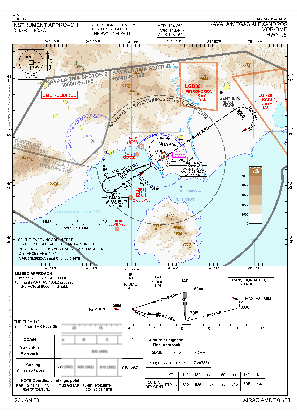
 IAC chart of LGKV
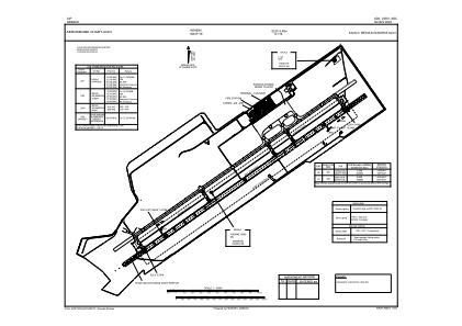
 ADC chart of LGKV
 Satellite view of LGKV

IAC chart of LGKVADC chart of LGKV
Satellite view of LGKV
Sorry, we have no imagery here.
Sorry, we have no imagery here.
Sorry, we have no imagery here.
Sorry, we have no imagery here.
Sorry, we have no imagery here.
Sorry, we have no imagery here.


LGKV - Kavala / Megas Alexandros
Located in Kavala, Greece
ICAO - LGKV, IATA - KVA
Data provided by AirmateGeneral information
Coordinates: N40°54'50" E24°37'11"
Elevation is 17 feet MSL.
View others Airports in Kavala
Operational data
Special qualification required
Current time UTC:
Current local time:
Weather
METAR: LGKV 240650Z 00000KT 8000 SCT008 BKN035 OVC070 12/11 Q1023
TAF: TAF LGKV 240500Z 2406/2506 21013KT 9999 SCT025 BKN080 PROB30 TEMPO 2406/2412 5000 RA FEW008 BKN020 BKN070 PROB30 TEMPO 2500/2506 5000 RA
Communications frequencies: [VIEW]
Runways:
| RWY identifier | QFU | Length (ft) | Width (ft) | Surface | LDA (ft) |
| 05 | 55° | 9843 | 148 | UNK | |
| 23 | 235° | 9843 | 148 | UNK |
Airport contact information
Address: Kavala Greece
Handlers

Other aviation service providers
Flight schools

Satellite view of LGKV
Sorry, we have no imagery here.
Sorry, we have no imagery here.
Sorry, we have no imagery here.
Sorry, we have no imagery here.
Sorry, we have no imagery here.
Sorry, we have no imagery here.