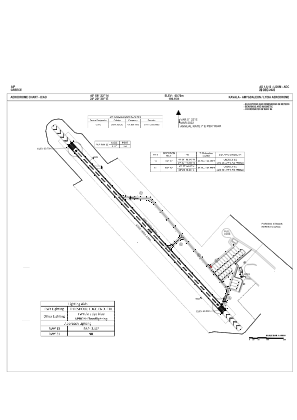
ADC chart of LGKM
 Satellite view of LGKM
Satellite view of LGKM
Sorry, we have no imagery here.
Sorry, we have no imagery here.
Sorry, we have no imagery here.
Sorry, we have no imagery here.
Sorry, we have no imagery here.
Sorry, we have no imagery here.


LGKM - Kavala / Amigdaleon Lydia
Located in Kavala, Greece
ICAO - LGKM, IATA -
Data provided by AirmateGeneral information
Coordinates: N40°58'23" E24°20'29"
Elevation is 199 feet MSL.
Magnetic variation is 5° East View others Airports in Kavala
Operational data
Special qualification required
Current time UTC:
Current local time:
Weather at : LGKV - Kavala / Megas Alexandros ( 24 km )
TAF: TAF LGKV 232300Z 2400/2424 21013KT 9999 SCT025 BKN080 PROB40 TEMPO 2404/2412 5000 RA FEW008 SCT020 BKN070 TEMPO 2418/2424 5000 RA
Communications frequencies: [VIEW]
Runways:
| RWY identifier | QFU | Length (ft) | Width (ft) | Surface | LDA (ft) |
| 13 | 137° | 4364 | 92 | UNK | |
| 31 | 317° | 4364 | 92 | UNK | |
| 32 | 0° | 0 | 0 | ASPH | |
| 14 | 0° | 0 | 0 | ASPH |
Airport contact information
Address: Kavala Greece
Satellite view of LGKM
Sorry, we have no imagery here.
Sorry, we have no imagery here.
Sorry, we have no imagery here.
Sorry, we have no imagery here.
Sorry, we have no imagery here.
Sorry, we have no imagery here.