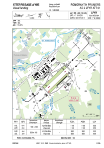
VAC chart of LFYR
 Satellite view of LFYR
Satellite view of LFYR
Sorry, we have no imagery here.
Sorry, we have no imagery here.
Sorry, we have no imagery here.
Sorry, we have no imagery here.
Sorry, we have no imagery here.
Sorry, we have no imagery here.


LFYR - Romorantin Pruniers
Located in Romorantin, France
ICAO - LFYR, IATA -
Data provided by AirmateGeneral information
Coordinates: N47°19'15" E1°41'20"
Elevation is 289 feet MSL.
Magnetic variation is 0.91° East View others Airports in Centre
Operational data
Special qualification required
Current time UTC:
Current local time:
Weather
METAR: LFYR 100230Z AUTO 03004KT 360V070 CAVOK 09/04 Q1025
Communications frequencies: [VIEW]
Runways:
| RWY identifier | QFU | Length (ft) | Width (ft) | Surface | LDA (ft) |
| 04L | 45° | 3609 | 328 | GRASS | |
| 22R | 225° | 3609 | 328 | GRASS | |
| 04R | 45° | 3117 | 328 | GRASS | |
| 22L | 225° | 3117 | 328 | GRASS |
Airport contact information
Address: Romorantin France
Fuel provider

Other aviation service providers
Aviation club (not for profit)

Satellite view of LFYR
Sorry, we have no imagery here.
Sorry, we have no imagery here.
Sorry, we have no imagery here.
Sorry, we have no imagery here.
Sorry, we have no imagery here.
Sorry, we have no imagery here.