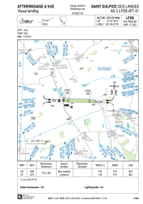
VAC chart of LFSS
 Satellite view of LFSS
Satellite view of LFSS
Sorry, we have no imagery here.
Sorry, we have no imagery here.
Sorry, we have no imagery here.
Sorry, we have no imagery here.
Sorry, we have no imagery here.
Sorry, we have no imagery here.


LFSS - Saint Sulpice Des Landes
Located in Bain De Bretagne, France
ICAO - , IATA -
Data provided by AirmateGeneral information
Coordinates: N47°47'30" W1°38'37"
Elevation is 312 feet MSL.
Magnetic variation is -0.14° East View others Airports in Pays-de-la-Loire
Operational data
Special qualification required
Current time UTC:
Current local time:
Weather at : LFRN - Rennes Saint Jacques ( 32 km )
METAR: LFRN 061200Z AUTO 35006KT 310V040 CAVOK 21/09 Q1017 NOSIG
TAF: TAF LFRN 061100Z 0612/0712 VRB05KT CAVOK TEMPO 0612/0618 02010KT PROB40 TEMPO 0700/0707 3000 BR
Communications frequencies: [VIEW]
Runways:
| RWY identifier | QFU | Length (ft) | Width (ft) | Surface | LDA (ft) |
| 09 | 92° | 2533 | 262 | GRASS | 2090 |
| 27 | 272° | 2533 | 262 | GRASS | 2156 |
Airport contact information
Address: Bain De Bretagne France
Other aviation service providers
Aviation club (not for profit)

Satellite view of LFSS
Sorry, we have no imagery here.
Sorry, we have no imagery here.
Sorry, we have no imagery here.
Sorry, we have no imagery here.
Sorry, we have no imagery here.
Sorry, we have no imagery here.