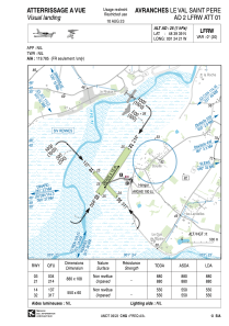
VAC chart of LFRW
 Satellite view of LFRW
Satellite view of LFRW
Sorry, we have no imagery here.
Sorry, we have no imagery here.
Sorry, we have no imagery here.
Sorry, we have no imagery here.
Sorry, we have no imagery here.
Sorry, we have no imagery here.


LFRW - Avranches Le Val Saint Pere
Located in , France
ICAO - LFRW, IATA -
Data provided by AirmateGeneral information
Coordinates: N48°39'39" W1°24'21"
Elevation is 25 feet MSL.
Magnetic variation is -0.14° East View others Airports in Lower Normandy
Operational data
Special qualification required
Current time UTC:
Current local time:
Weather at : LFRD - Dinard Pleurtuit Saint Malo ( 50 km )
METAR: LFRD 070530Z AUTO VRB03KT 4600 BR NSC 04/04 Q1021 TEMPO 0400 FG VV///
TAF: TAF LFRD 070500Z 0706/0806 VRB05KT CAVOK TEMPO 0706/0707 2000 BR PROB40 TEMPO 0706/0707 0400 FG VV/// BECMG 0712/0714 02010KT BECMG 0720/0722 VRB05KT TEMPO 0800/0806 2000 BR PROB40 TEMPO 0802/0806 0400 FG VV///
Communications frequencies: [VIEW]
Runways:
| RWY identifier | QFU | Length (ft) | Width (ft) | Surface | LDA (ft) |
| 14 | 137° | 1804 | 197 | GRASS | |
| 32 | 317° | 1804 | 197 | GRASS | |
| 03 | 34° | 2887 | 354 | GRASS | |
| 21 | 214° | 2887 | 354 | GRASS |
Airport contact information
Address: France
Other aviation service providers
Aviation club (not for profit)

Aéroclub des Grèves du Mont St Michel
Aéroclub des Grèves du Mont St Michel
mesphil@wanadoo.fr+33233580291
Satellite view of LFRW
Sorry, we have no imagery here.
Sorry, we have no imagery here.
Sorry, we have no imagery here.
Sorry, we have no imagery here.
Sorry, we have no imagery here.
Sorry, we have no imagery here.