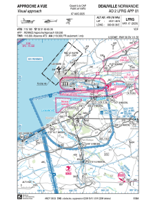
VAC chart of LFRG
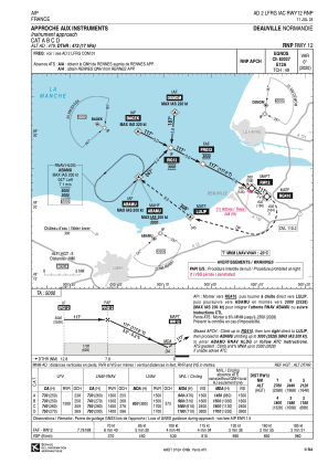
 IAC chart of LFRG
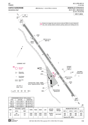
 ADC chart of LFRG
 Satellite view of LFRG
IAC chart of LFRGADC chart of LFRG
Satellite view of LFRG
Sorry, we have no imagery here.
Sorry, we have no imagery here.
Sorry, we have no imagery here.
Sorry, we have no imagery here.
Sorry, we have no imagery here.
Sorry, we have no imagery here.


LFRG - Deauville Normandie
Located in Deauville, France
ICAO - LFRG, IATA - DOL
Data provided by AirmateGeneral information
Coordinates: N49°21'48" E0°9'36"
Elevation is 479 feet MSL.
Magnetic variation is 0.31° East View others Airports in Lower Normandy
Operational data
Special qualification required
Current time UTC:
Current local time:
Weather
METAR: LFRG 300500Z AUTO 22008KT 9999 OVC009 08/06 Q1021
Communications frequencies: [VIEW]
Runways:
| RWY identifier | QFU | Length (ft) | Width (ft) | Surface | LDA (ft) |
| 12 | 117° | 8366 | 148 | MACADAM | 6890 |
| 30 | 297° | 8366 | 148 | MACADAM | 6988 |
Airport contact information
Address: Deauville France
Handlers

Other aviation service providers
Aviation club (not for profit)

Satellite view of LFRG
Sorry, we have no imagery here.
Sorry, we have no imagery here.
Sorry, we have no imagery here.
Sorry, we have no imagery here.
Sorry, we have no imagery here.
Sorry, we have no imagery here.