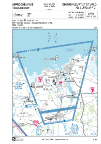
VAC chart of LFRD
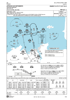
 IAC chart of LFRD
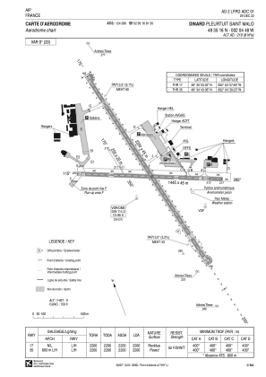
 ADC chart of LFRD
 Satellite view of LFRD

IAC chart of LFRDADC chart of LFRD
Satellite view of LFRD
Sorry, we have no imagery here.
Sorry, we have no imagery here.
Sorry, we have no imagery here.
Sorry, we have no imagery here.
Sorry, we have no imagery here.
Sorry, we have no imagery here.


LFRD - Dinard Pleurtuit Saint Malo
Located in Dinard, France
ICAO - LFRD, IATA - DNR
Data provided by AirmateGeneral information
Coordinates: N48°35'16" W2°4'48"
Elevation is 219 feet MSL.
Magnetic variation is -0.36° East View others Airports in Brittany
Operational data
Special qualification required
Current time UTC:
Current local time:
Weather
METAR: LFRD 282130Z AUTO 07005KT 040V100 CAVOK 04/02 Q1028 NOSIG
TAF: TAF LFRD 281700Z 2818/0118 04010KT 9999 FEW040 BECMG 2822/2824 VRB05KT TEMPO 0100/0107 3000 BR PROB40 TEMPO 0102/0107 0400 FG VV/// BECMG 0106/0109 06010KT PROB30 TEMPO 0116/0118 06015G25KT
Communications frequencies: [VIEW]
Runways:
| RWY identifier | QFU | Length (ft) | Width (ft) | Surface | LDA (ft) |
| 17 | 170° | 7218 | 148 | CONC+ASPH | 7218 |
| 35 | 350° | 7218 | 148 | CONC+ASPH | 7218 |
| 12 | 115° | 4741 | 148 | CONC+ASPH | 4741 |
| 30 | 295° | 4741 | 148 | CONC+ASPH | 4232 |
| 17R | 170° | 656 | 66 | GRASS | 656 |
| 35L | 350° | 656 | 66 | GRASS | 656 |
Airport contact information
Address: Dinard France
Handlers

Other aviation service providers
Aviation club (not for profit)

Aéroclub de la Côte d'Emeraude
Aéroclub de la Côte d'Emeraude
laurent.le.tynevez1@libertysurf.fr+33231082902
Aviation medical examiner

Satellite view of LFRD
Sorry, we have no imagery here.
Sorry, we have no imagery here.
Sorry, we have no imagery here.
Sorry, we have no imagery here.
Sorry, we have no imagery here.
Sorry, we have no imagery here.