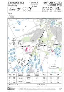
VAC chart of LFQN
 Satellite view of LFQN
Satellite view of LFQN
Sorry, we have no imagery here.
Sorry, we have no imagery here.
Sorry, we have no imagery here.
Sorry, we have no imagery here.
Sorry, we have no imagery here.
Sorry, we have no imagery here.


LFQN - Saint Omer Wizernes
Located in Saint-Omer, France
ICAO - LFQN, IATA - XSG
Data provided by AirmateGeneral information
Coordinates: N50°43'44" E2°14'4"
Elevation is 249 feet MSL.
Magnetic variation is 0.88° East View others Airports in Nord-Pas-de-Calais
Operational data
Special qualification required
Current time UTC:
Current local time:
Weather at : LFAC - Calais Marck ( 33 km )
METAR: LFAC 130700Z AUTO 21012KT 5000 BR FEW009 OVC049 11/09 Q1003
Communications frequencies: [VIEW]
Runways:
| RWY identifier | QFU | Length (ft) | Width (ft) | Surface | LDA (ft) |
| 09 | 87° | 1959 | 66 | ASPH | 1959 |
| 27 | 267° | 1959 | 66 | ASPH | 1795 |
| 03 | 27° | 2100 | 164 | GRASS | 1673 |
| 21 | 207° | 2100 | 164 | GRASS | 1772 |
Airport contact information
Address: Saint-Omer France
Other aviation service providers
Aviation club (not for profit)

Aviation medical examiner

Satellite view of LFQN
Sorry, we have no imagery here.
Sorry, we have no imagery here.
Sorry, we have no imagery here.
Sorry, we have no imagery here.
Sorry, we have no imagery here.
Sorry, we have no imagery here.