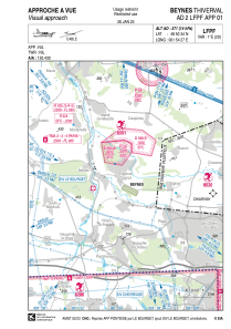
VAC chart of LFPF
 Satellite view of LFPF
Satellite view of LFPF
Sorry, we have no imagery here.
Sorry, we have no imagery here.
Sorry, we have no imagery here.
Sorry, we have no imagery here.
Sorry, we have no imagery here.
Sorry, we have no imagery here.


LFPF - Beynes Thiverval
Located in Beynes, France
ICAO - LFPF, IATA -
Data provided by AirmateGeneral information
Coordinates: N48°50'34" E1°54'27"
Elevation is 371 feet MSL.
Magnetic variation is 0.89° East View others Airports in Île-de-France
Operational data
Special qualification required
Current time UTC:
Current local time:
Weather at : LFPN - Toussus Le Noble ( 18 km )
METAR: LFPN 110630Z AUTO 07003KT 030V100 CAVOK 19/13 Q1022 NOSIG
TAF: TAF LFPN 110500Z 1106/1115 04008KT CAVOK
Communications frequencies: [VIEW]
Runways:
| RWY identifier | QFU | Length (ft) | Width (ft) | Surface | LDA (ft) |
| 12 | 115° | 3281 | 262 | GRASS | 3150 |
| 30 | 295° | 3281 | 262 | GRASS | 2887 |
Airport contact information
Address: Beynes France
Satellite view of LFPF
Sorry, we have no imagery here.
Sorry, we have no imagery here.
Sorry, we have no imagery here.
Sorry, we have no imagery here.
Sorry, we have no imagery here.
Sorry, we have no imagery here.