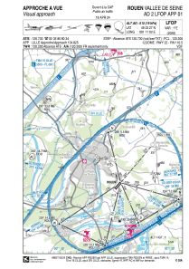
VAC chart of LFOP
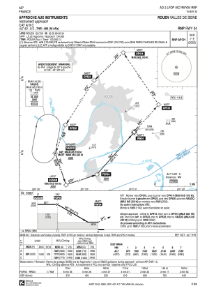
 IAC chart of LFOP
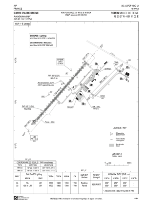
 ADC chart of LFOP
 Satellite view of LFOP
IAC chart of LFOPADC chart of LFOP
Satellite view of LFOP
Sorry, we have no imagery here.
Sorry, we have no imagery here.
Sorry, we have no imagery here.
Sorry, we have no imagery here.
Sorry, we have no imagery here.
Sorry, we have no imagery here.


LFOP - Rouen Vallee De Seine
Located in Rouen, France
ICAO - LFOP, IATA - URO
Data provided by AirmateGeneral information
Coordinates: N49°23'27" E1°11'2"
Elevation is 512 feet MSL.
Magnetic variation is 0.63° East View others Airports in Upper Normandy
Operational data
Special qualification required
Current time UTC:
Current local time:
Weather
METAR: LFOP 092330Z AUTO 04008KT CAVOK 05/04 Q1028
Communications frequencies: [VIEW]
Runways:
| RWY identifier | QFU | Length (ft) | Width (ft) | Surface | LDA (ft) |
| 05 | 47° | 2953 | 262 | GRASS | 2674 |
| 23 | 227° | 2953 | 262 | GRASS | 2674 |
| 04 | 41° | 5577 | 148 | BITUM | 5577 |
| 22 | 221° | 5577 | 148 | BITUM | 5577 |
Airport contact information
Address: Rouen France
Handlers

Other aviation service providers
Aviation club (not for profit)

Aviation medical examiner

Satellite view of LFOP
Sorry, we have no imagery here.
Sorry, we have no imagery here.
Sorry, we have no imagery here.
Sorry, we have no imagery here.
Sorry, we have no imagery here.
Sorry, we have no imagery here.